

Welcome
The Cartography and Imaging Sciences Discipline Node (aka "Imaging Node") of the Planetary Data System is the curator of NASA's primary digital image collections from past, present and future planetary missions. Imaging provides to the NASA planetary science community the digital image archives, ancillary data, sophisticated data search and retrieval tools, and cartographic and technical expertise necessary to develop and fully utilize the vast collection of digital planetary images of many terrestrial planetary bodies, including icy satellites. Imaging science expertise includes orbital and landed camera instrument development and data processing, data engineering and informatics, planetary remote sensing at UV to RADAR wavelengths, and cartographic and geospatial data analysis and product development. For a guide to Imaging Node services download the PDS Imaging Node Tour.
Image of the Week

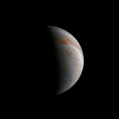
Crescent Jupiter with the Great Red Spot
This image of a crescent Jupiter and the iconic Great Red Spot was created by a citizen scientist (Roman Tkachenko) using data from Juno's JunoCam instrument. The image was taken on Dec. 11, 2016 at 2:30 p.m. PST (5:30 p.m. EST), as the Juno spacecraft performed its third close flyby of Jupiter.
NASA/JPL-Caltech/SwRI/MSSS/Roman Tkachenko
Latest News
 Juno Release #1
January 17, 2017: JunoCam data are now available via the Cartography and Imaging Sciences Node
online data volumes. Visit the PDS Juno Mission page here.
 Atlas Content-Based Searches
January 6, 2017: Content-based searches are now available through the Image Atlas for MRO/HiRISE (Landmarks), MSL Mastcam, Cassini ISS, and Galileo SSI. Searches are powered by neural network content classifiers. Go to http://pds-imaging.jpl.nasa.gov/search/ and select one of the content tabs on the left nav bar to select the desired image class.
Cassini ISS, RADAR & VIMS
Release #48
January 5, 2017: Cassini data covering Jan. 1, 2016 through March 31, 2016, have been released at the PDS Imaging Node for ISS volumes 102 & 103, RADAR volume 274, and VIMS volumes 78. Search capability is also available via the Image Atlas.
Mars Odyssey Release #57
January 3, 2017: The 57th Mars Odyssey release has occurred. The data may be accessed at the online data volumes and via the Image Atlas. This data is accumulating.Mars Exploration Rover (MER) Release #50
December 19, 2016: Data for the latest MER release, acquired on Sols 4321-4410. The data is now available through the online data volumes and via the Image Atlas. This data is accumulating.Lunar Reconnaisance Orbiter (LRO) Release #28
December 15, 2016: Data for LRO LAMP and LRO LROC are now available via the online data volumes and the Planetary Image Atlas. PDS Tool Registry
December 7, 2016: The Planetary Data System is pleased to announce the PDS Tool Registry. This interface allows the user to search for and discover tools relating to the access and use of planetary data. The interface also allows tool providers to submit their software for inclusion in the registry.
Mars Science Laboratory (MSL)
Release #13
December 5, 2016: Data acquired through Sol 1417 is now available for MSL HAZCAM, NAVCAM, Mastcam, MAHLI, and MARDI and are available via the Image Atlas. PLACES data are also available for Sites 1-56.
Mars Reconnaissance Orbiter (MRO) Release #39
December 1, 2016: The 39th MRO release has occurred for CTX and MARCI for data acquired March 16-May 16, 2016. The data can be accessed via the online data volumes. HiRISE data is available via the Image Atlas.Version 2 of VICAR Image Processing Release
July 25, 2016: We are pleased to announce the release of Version 2 of VICAR (Video Image Communication and Retrieval), a general purpose image processing software system developed at the Jet Propulsion Laboratory. Notable changes in this release include:* Pre-built binaries for 32- and 64-bit Linux
(Red Hat 5.10), and Mac OS X
* Three new application programs
* 73 changes, updates, or bug fixes
* Three new use cases (examples) in the
manual
- Landsat mosaic
- SRTM mosaic
- Noise reduction for Voyager images
For more information please visit:
http://www-mipl.jpl.nasa.gov/vicar_open.html. Questions about VICAR, contact: vicar_help@jpl.nasa.gov.