Welcome to the Jupiter Archive Page!
This page is designed to serve as a resource for accessing a variety of Jovian atmospheric data sets housed at the PDS Atmospheres Node. For additional information and to access datasets not housed in the Atmospheres Node, users are encouraged to explore the search engine on the PDS home page http://starbrite.jpl.nasa.gov/pds/index.jsp (Note: DON'T FORGET TO FILTER your mission, target and instrument selections) or go to the appropriate discipline node:
- Imaging - http://pds-imaging.jpl.nasa.gov/
- PPI - http://pds-ppi.igpp.ucla.edu/
- Rings - http://pds-rings.seti.org/
The data sets listed below are in roughly reverse chronological order by mission, with groundbased data following all of the spacecraft mission data.
Tools
The tools that are cited below will help you access the data that is stored in various formats.
Some tools that might be useful for viewing/displaying data:
fv - FITS Viewer http://heasarc.gsfc.nasa.gov/docs/software/ftools/fv/
ds9 - FITS Viewer http://ds9.si.edu/site/Home.html
NASAView - PDS tool that will view files with PDS labels https://pds.jpl.nasa.gov/tools/software_download.cfm
Vicar - The main VICAR web site is http://www-mipl.jpl.nasa.gov/external/vicar.html
There is also an IDL routine called "read_vicar.pro" that will read in VICAR image files. There is a supporting routine called "vicgetpars.pro" that must be in the same directory (or in the IDL path).
The command to read one of the Cassini maps would be:
image = read_vicar('n1355374081_map.pro', label, /flip) After executing this command, the IDL variable "image" would contain the image array. The variable "label" will be a single string containing the VICAR header, and the "/flip" parameter will allow the image to display right-side-up in IDL, which counts image lines from the bottom up, rather than from the top down, like VICAR.
The Cassini maps described below were all created on a Linux architecture, so some users may have to byteswap the data before it appears correctly in IDL. There are IDL routines for this. Also, the data is halfword (16 bit), so it may not display correctly on 8-bit monitors unless it is scaled.
New Horizons
Because New Horizons is first and foremost a mission to Pluto, the PDS Small Bodies Node is the lead node for archiving all New Horizons data, even those data acquired during the Jupiter flyby in February 2007. However, in addition to the Small Bodies Node New Horizons web page (link here), we have developed a New Horizons Jupiter Resource Page (link here) for scientists interested in the data from the Jupiter encounter. (Note: these data are in FITS format).
Cassini
Mission Data
The Atmospheres Node is the lead node for all of the Cassini archive, and is responsible for archiving the CIRS, UVS, and RSS data. See our Cassini Archive Page for more details about the Cassini archive. To directly access the Jupiter data from Cassini that are archived at the Atmospheres Node, see the Jupiter section of the PDS Atmospheres Node Catalog.
High Resolution Maps
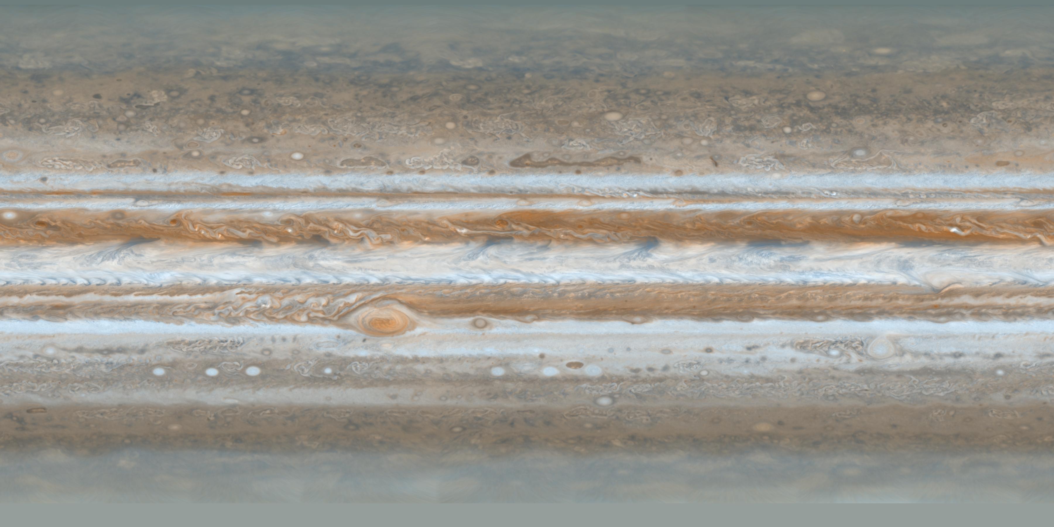
This Cassini dataset is a set of map projections, derived from volume CO-E/V/J-ISSNA-2-EDR-V1, which contains Imaging Science Subsystem - Narrow Angle (ISS-NA) images near closest approach during the Jupiter Cassini flyby. The observing sequence used a 1x2 mosaic, oriented N-S, with 4 filters, and returned 8 images every 63 minutes for 40 hours. At each time step the ISS acquired a complete view of the planet for a total of 304 images, which resulted in 302 useful maps (for more information). (Note: These data are in VICAR format).
Gridded and nongridded color reference images provide a basis for assessing the data. These geometrically controlled maps are not photometrically accurate (illumination has been removed and seam removal processing applied). The rectangular map is projected in equal increments of planetocentric latitude and Sys. III west longitude, and extend +/- 90 deg. in latitude and 360 degrees in longitude.
PIA07782.tif (19.46 MB) or PIA07782.jpg (441.3 KB) and PIA07782_fig2 (784 KB - gridded)
Click here to access the aforementioned Cassini data.
Note: This conditional data set has been partially reviewed and is available for your use. Improvements of the data set will be added as available. Constructive criticism is appreciated.
Galileo
Mission Data
The Atmospheres Node is responsible for archiving the Galileo PPR and Probe data. See our Galileo Archive Page for newly released Galileo data. To directly access the Jupiter data from Galileo that are archived at the Atmospheres Node, see the Jupiter section of the PDS Atmospheres Node Catalog.
UVS/EUV
The Galileo UVS/EUV data sets consist of Jupiter Orbit Operations data from two instruments: the Ultraviolet Spectrometer and the Extreme Ultraviolet Spectrometer. The UVS was mounted on the scan platform and aligned with the other platform instruments; it has three channels: F covers 162.0 to 323.1 nm, G covers 113.3 to 192.1 nm and N covers 282.0 to 432.0 nm. The G and N slits are 0.1 by 1.0 deg and F is 0.1 by 0.4 deg. The EUV was mounted on the spinning section of the spacecraft and swept the sky, depending on spin rate, in sectors whose length (perpendicular to the spin direction) is 0.86 deg and whose spin resolution is 0.17 deg. The grating covers 54 to 128 nm.
A very detailed description of the science objectives for each observation for each instrument is given in the catalog files uvsinst.cat and euvinst.cat. EUV observations centered on the Io Torus along with Jupiter and moon volatile escape and surface albedo measurements; Auroral observations were obtained in later orbits. EUV All sky Solar Wind measurements were obtained. The UVS obtained a diverse set of measurements on Jupiter and the moons, including stratospheric aerosols, airglow, aurora, Jovian magnetosphere and Io Torus, as well as satellite measurements of volatile escape, surface albedo and composition.
Volume 1 covers UVS and EUV pre-Jupiter, cruise observationsVolume 2 covers UVS and EUV for Jupiter orbits from JA to E11
Volume 3 covers UVS for orbits through C20 and EUV through I33
The UVS data acquired during the Cruise phase of the Galileo mission can be found here, while the UVS and EUV data acquired during the Jupiter Orbital phase of the mission can be accessed here.
Note: This conditional dataset has been assigned shortened file names, which will be revised to correspond to the original Galileo file names since PDS standards now allow this. For those who are used to the Galileo nomenclature, the data is temporarily available at the LASP site at http://lasp.colorado.edu/galileo.
Atmospheric Image Cubes
This data set contains uniformly mapped mosaics constructed from photometrically and geometrically calibrated images. The mosaics include most of the images of Jupiter's atmosphere that were obtained by the Galileo orbiter. Most mosaics are simple cylindrical projections (mosaics of the limb regions were also presented as orthographic projections). The data are arranged as a cube with co-registered multi-color projections in the front planes (some of the following filters are included - violet, green, clear, 725, 756 and 889) and, pixel-by-pixel, planetographic latitude, west longitude, cosine of emission angle, cosine of incidence angle, and cosine of phase angle are stored in the back planes. These data are stored as FITS files. (more information - download GalileoMaps.doc). There is also a table - download GalileoMaps.xls of parameters of these mosaics.
Note: This conditional data set has been partially reviewed and is available for your use. Improvements of the data set will be added as available. Constructive criticism is appreciated.
Click here to access the aforementioned mapped Galileo data.
IRTF Ground-based Support Observations
This dataset contains the Orton et al IRTF Galileo support monitoring images taken with the NSFCAM, a 256 x 256 InSb array. Plate scales of 0.3, 0.15 and 0.06 arcseconds with the 3-meter IRTF telescope. The data are in FITS format and browse images are included as arrays of thumb nail images.
Note: This conditional data set has been partially reviewed and is available for your use. Constructive criticism is appreciated.
Click here to access the aforementioned IRTF data.
Voyager
Mission Data
The Atmospheres Node is responsible for archiving the Voyager IRIS and UVS data. To directly access the Voyager Jupiter data that are archived at the Atmospheres Node, see the Jupiter section of the PDS Atmospheres Node Catalog.
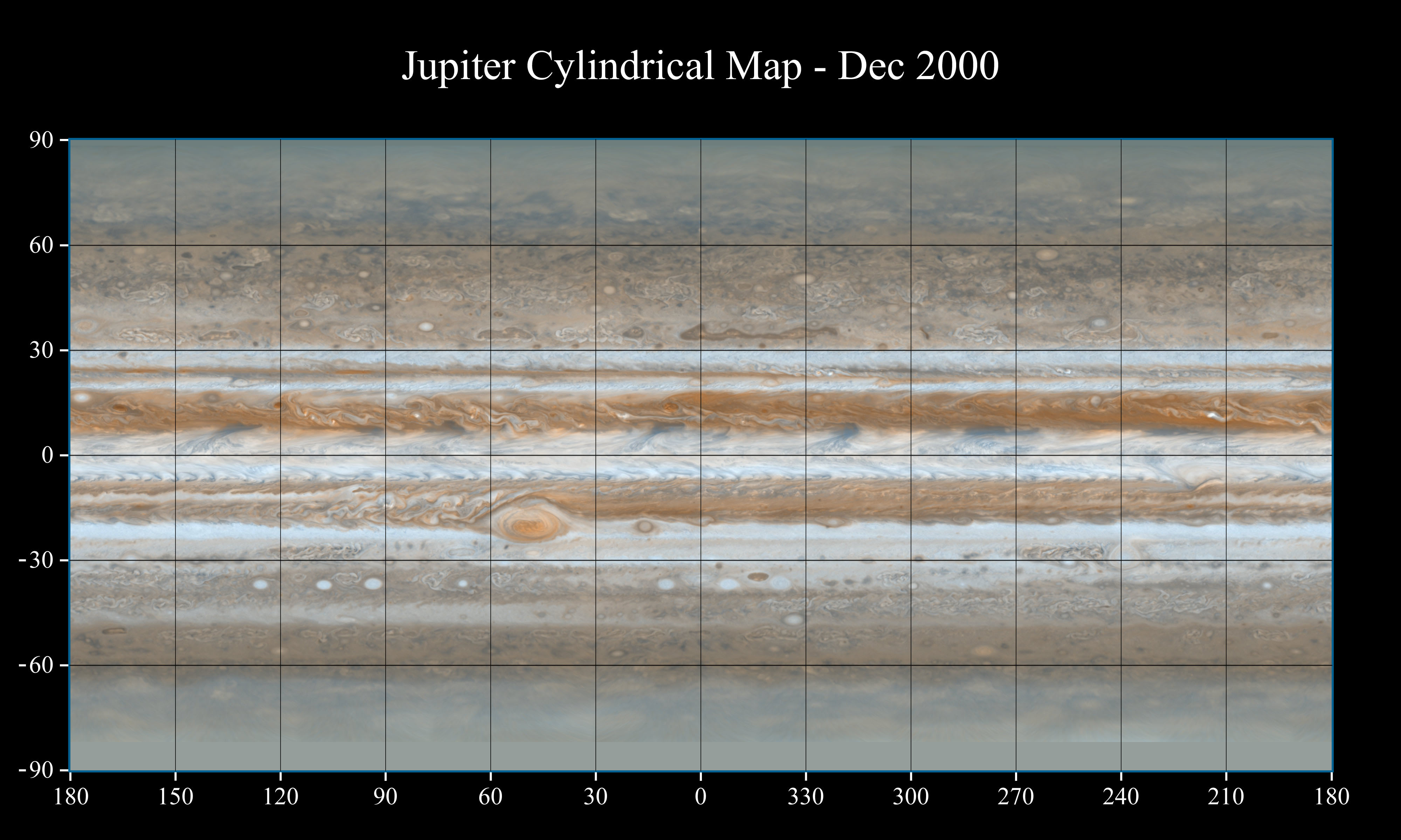
Voyager 1 & 2 Atmospheric Maps
These mosaics were assembled to provide a consistent set of data for studies of Jovian atmospheric dynamics. This data includes the early approach of Voyager 1 and 2 when the entire disc could be imaged in one narrow-angle frame through the period when 2 X 2 mosaics were required to cover the planet. Limb-darkening due to solar insolation angle and cloud scattering effects has been analytically removed and the regions in each of 6 adjacent sets of observations have been integrated into each cylindrical map. Earlier Blue(480+/-50nm) Voyager 1 and violet (400+/-50nm) and ultraviolet(325+/-45nm) for later Voyager 1 and Voyager 2 mosaics were used. They are projected at 9 pixels/deg (more information - download VoyagerMosaic.doc).
Note: This conditional data set has been partially reviewed and is available for your use. Improvements of the data set will be added as available. Constructive criticism is appreciated.
Click here to access the aforementioned Voyager maps dataAccess to Calibrated Voyager Images
An effort to provide geometrically corrected and photometrically calibrated data of the planet Jupiter is underway. It is not in PDS format. If after searching the PDS Imaging node data at http://pds-imaging.jpl.nasa.gov/Missions/Voyager_mission.html or using the PDS Rings Node thumbnail search at http://pds-rings.seti.org/catalog/vgriss.html, you have identified specific FDS numbers, the PDS ATMOS node can make specified files available.
Shoemaker-Levy 9 Jupiter Impact Data
The PDS Atmospheres Node has already archived two datasets from the Shoemaker-Levy 9 impacts into Jupiter in July 1994. One dataset contains the Hubble Space Telescope observations of this event, while the other contains ground-based observations of the event made with the Anglo-Australian Observatory. These data can be accessed from the Jupiter section of the PDS Atmospheres Node Catalog.
Several additional datasets are conditionally online pending peer review; these include ground-based data from the W. M. Keck Observatory, the National Solar Observatory, the South African Astronomical Observatory, and the South Pole InfraRed EXplorer. These data can be accessed here.
Ground-based Data
Maui Observations
Mars, Jupiter, and Saturn were imaged between 2001 and 2005 using the unique combination of high spatial resolution obtainable from the AEOS 3.6-meter adaptive optics telescope and two carefully selected narrow bandpass filters that were chosen for their sensitivity to different altitudes in the giant planet atmospheres. The central wavelengths of the two filters used for this investigation were 727 and 751 nm. The data were taken in a service observing mode by AEOS personnel in between observations of other Air Force targets, and they comprise a ground-based temporal timeline for planets currently undergoing an intense period of scrutiny with NASA spacecraft. The high spatial resolution capability of the AEOS telescope yields a data set that can enhance our understanding of the these planets' atmospheric dynamics, vertical structure, and thermal balance. The raw AEOS/VisIm images are archived as FITS files with detached labels.
These data can be accessed here
Tortugas Mountain Observations
This multicolor data set (450-893 nm) reveals the episodic nature of cloud phenomena in Jupiter's visible cloud deck. It was obtained at Tortugas Mountain Observatory and spans the period from 1988 to 1997.
The observatory's 61 cm Cassegrain camera was used with a CCD detector illuminated at the f/40 focus, resulting in a plate scale = 9.381 x 10**-7 rad/pixel. Each image has been flat-fielded, the image scale and orientation determined and a limb-finding algorithm applied to determine planet center and viewing geometry . (more information).
Note: This conditional data set has been partially reviewed and is available for your use. Improvements of the data set will be added as available. Constructive criticism is appreciated.
Click here to access the aforementioned Tortugas Mountain data.
Karkoschka's Full Disk Albedo Measurements
The PDS Atmospheres Node has archived methane absorption coefficients and full-disk albedo measurements of Jupiter (along with Saturn, Uranus, Neptune, and Titan) spanning 300 to 1000 nm.
These observations were made by Erich Karkoschka from the European Southern Observatory in July 1995. These data can be accessed from the Jupiter section of the PDS Atmospheres Node Catalog.
