PDS Organization
The Planetary Data System is organized as a federation of 8 Nodes. In addition, Subnodes have been established to help the Nodes in some science discipline areas. And some of the Nodes oversee one or more Data Nodes, which are set up as a short-term facility to deliver specific data sets for archiving in the PDS.
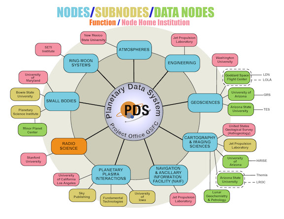
Organizational Diagram
The following diagram shows the organization relationships among the Nodes, Subnodes, and Data Nodes, and the institutions at which they are located.
Details About the PDS Nodes
| PDS Project Management | The PDS Project Management resides at Goddard Space Flight Center in the Solar System Exploration Data Services Office, Code 690.1 |
| Engineering Node | The Planetary Data System (PDS) is a distributed information system with the Engineering Node located at the Jet Propulsion Laboratory in Pasadena, California. The Engineering Node provides systems engineering support to the entire PDS, handling global aspects such as standards (data, software, documentation, operating procedures), technology investigations, coordination and development of system-wide software, coordination of data ordering and distribution, catalog development and implementation, and maintenance of the PDS catalogs. |
| Atmospheres Node | The Planetary Atmospheres Node is responsible for the acquisition, preservation, and distribution of all non-imaging atmospheric data from all planetary missions (excluding Earth observations). The primary goal of the node is to make available to the research community the highest quality data possible. The data are reviewed and reformatted where necessary in order to meet the documentation and quality standards established by the PDS. |
| Geosciences Node | The Geosciences Node maintains data sets that are relevant to the geosciences discipline, the study of the surfaces and interiors of terrestrial planetary bodies. The Node works with planetary missions to help ensure that their geoscience data sets are properly documented and archived. The Node also restores and publishes selected data sets from past missions that are in danger of being lost. The Geosciences Node also provides information and expert assistance to researchers, and answers questions from the interested non-scientists as well. Derived image data, geophysics data, microwave data, spaceborne thermal data and spectroscopy data are archived at the lead node or at one of the subnodes. |
| Navigation and Ancillary Information Facility (NAIF) Node | The NAIF Node is responsible for design and implementation of the SPICE concept--a means for archiving, distributing and accessing observation geometry and related ancillary data used in mission design, mission evaluation, observation planning and science data analysis. Under PDS funding NAIF serves as the "ancillary data node"-- archiving and distributing the SPICE kernel files produced by numerous flight projects. SPICE kernel file distributions are accompanied by the latest NAIF Toolkit software. NAIF also produces and distributes generic ephemeris data sets for planets, satellites, comets and asteroids, using appropriate products of JPL's Solar System Dynamics Group as sources. |
| Cartography and Imaging Sciences Node | The Cartography and Imaging Sciences Node maintains and distributes the archives of planetary image data acquired from NASA's flight projects with the primary goal of enabling the science community to perform image processing and analysis on the data. The Node provides direct and easy access to the digital image archives through on-line remote-access tools by way of Internet services. The Cartography and Imaging Sciences Node provides digital image processing tools and the expertise and guidance necessary to understand and use the image collections. The Node is responsible for restoring data sets from past missions in danger of being lost. They also work with active flight projects to assist in the creation of their archive products and to ensure that their products and data catalogs become an integral part of the Cartography and Imaging Sciences Node's data collections. |
| Planetary Plasma Interactions Node | The Planetary Plasma Interactions (PPI) Node is responsible for acquisition, preservation, and distribution of fields and particle data from all planetary missions. The primary goal of the PPI Node is to make available to the research community the highest quality data possible. To insure the highest quality data, all data are reviewed and where necessary, reformatted to meet the quality standards established by the PDS. |
| Ring-Moon Systems Node | The Planetary Ring-Moon Systems Node is devoted to archiving and distributing scientific data sets relevant to planetary ring systems. The two major classes of ring data are images and occultation profiles, although a variety of additional data types (e.g. spectra, particle absorption signatures, etc.) are also of interest. A large fraction of our data sets are from the Voyager missions to the outer planets, but Earth-based and HST data sets are also represented. The Ring-Moon Systems Node also performs a variety of services to support research into these data sets. These services include developing on-line catalogs and information systems, filling orders for data, developing software tools, and coordinating special observing campaigns. |
| Small Bodies Node | The Small Bodies Node (SBN) is a distributed node that curates data sets and provides consulting expertise for comets, asteroids, and interplanetary dust. The Comet Subnode is located at the University of Maryland College Park. In addition to maintaining the combined archives of the SBN and supporting the SBN web site, the Comet subnode collects, formats, verifies and consults on datasets concerned with comet observations as well as providing support for active comet missions and observing campaigns. The Asteroid/Dust Subnode is located at the Planetary Science Institute in Tucson, Arizona. The Asteroid/Dust subnode collects, formats, verifies and reviews ground based and mission data pertaining to asteroids, transneptunians, small planetary satellites and interplanetary dust. |